|
|
|

SKAHA BLUFFS NORTHERN ACCESS
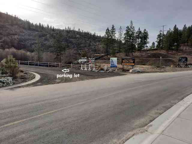
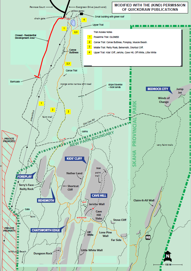
Turn east from South Main Street and wind your way up Pineview Road until you are forced to turn right onto Evergreen Drive (about 1.5 km). Follow this for about 500 m to the start of The Bluffs at Skaha housing development construction site (please do not enter this). Note: This is a day use area and camping and overnight parking is not permitted. The developers of The Bluffs at Skaha, donated 65 ha of land as an ecological gift to Skaha Bluffs Provincial Park. The donated land extends approximately from the southern end of Little White northwards to the Gas Pipeline Road and includes many significant crags that were previously on private land (see map below). As part of the arrangement, the developers also donated land to the City of Penticton as 'green space'. This comprises a narrow (approx.10 m wide) corridor of land that follows The Canoe Trail (see map below) and which will provide access from the Evergreen parking lot to the Skaha Bluffs Provincial Park when all the legal details are completed. The trails currently open to climbers are shown on the attached map, taken and modified with permission from Marc Bourdon's guidebook "Skaha Climbing" (p.133). (Note that The Middle and Upper Trails (trails 3 and 4) cross private land. Fortunately the current owners have placed no restrictions on their use by hikers, climbers and mountain bikers.) The Powerline Trail (#1): This trail is now closed; please do not use.
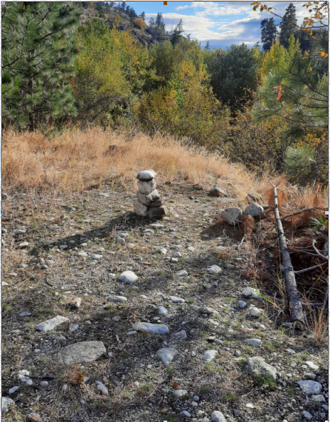
The Canoe Trail (#2) Look for a cairn on the edge of the embankment just east of the powerline. This marks the start of a trail that heads steeply down the embankment, skirts the east side of a small pond/wetland, jogs right, and then joins the original Canoe Trail at the southern end of the pond. The trail passes several attractive crags on the right (watch out for poison ivy!) before the valley widens, transitions into an old dirt road, and starts to climb uphill. Not far up this road (~ 50 m) a cairn and a reflective trail marker on a tree on the right indicate where The Canoe Trail branches off to the right and cuts across a terrace to join the powerline road near its junction with the Gas Line road.
The Middle Trail (#3): This is the continuation of the dirt road after the Canoe Trail branches off to the right. After about 5 minutes it crosses the Gas Line road (the soon to be new northern boundary of the Park) and then continues on the other side. A few minutes more brings you to a trail on the left that leads to Shortcut Cliff and Behemoth. Straight ahead brings you to Reilly Rock and Foreplay South. The Upper Trail (#4): Starts in the SE corner of the parking lot, a few metres east of the start of The Canoe Trail described above. (Note: At the bottom of the short hill at the start of this trail is a trail that branches off to the right and cuts over to The Canoe Trail. This will probably become the "official" start to The Canoe Trail as it is not as steep and prone to erosion as the trail that cuts down from the cairn depicted in the photo above.)
and possessions safe while you enjoy your time at the Bluffs.
|